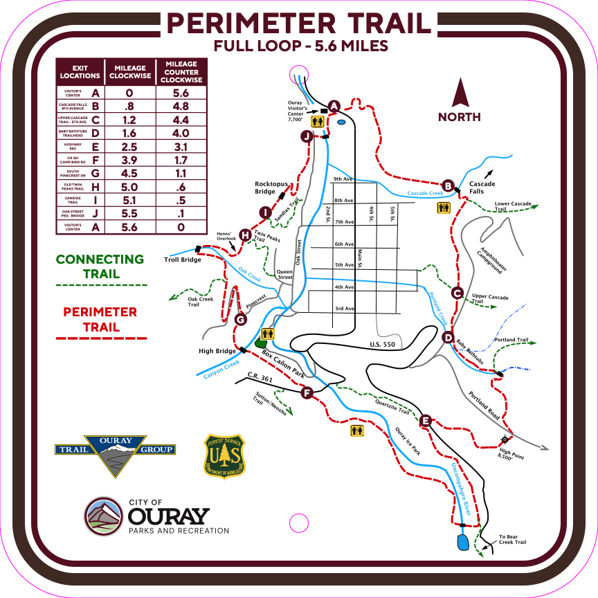
Ouray Perimeter Trail

Trail Details
| Round Trip | 5.6 miles |
| Starting Altitude | 7,700ft |
| Highest Point | 8,500ft |
| Elevation Gain | 1,800ft |
| Round Trip | 4-5 hours |
TRAILHEAD:
The trail begins across from the Ouray Visitors’ Center on the east side of US 550. A parking lot is on the east side of the road. To hike the trail clockwise (you get the hardest part of the trail out of the way first), the trail starts out of the parking lot. If you want to hike the trail counterclockwise, cross Highway 550, go through the pool parking lot and cross the bridge over the Uncompahgre River near the City of Ouray Maintenance Buildings where you will find a kiosk near the trail entrance on Oak Street. There are many different exit points into the City of Ouray that are marked with an (♦) in the following text if you would like to hike parts of trail at different times. The following directions are for hiking the trail in a clockwise direction.
ATTRACTIONS AND FEATURES:
♦ denotes exit point
To begin from the trail parking lot, walk up the wood stairs on the east side of the hillside to Cascade Cliff (also called the Pool Wall). Hike south on the cliff path 0.8 miles to Cascade Cade and Cascade Creek bridge♦. Cross the bridge and continue uphill 0.4 miles to an intersection where the Cascade Trail heads east and the Perimeter Trail turns right. Cross the 5th Avenue Trail♦ and continue hiking to the Amphitheater Campground Road (0.1 miles). Turn right and walk down the road 0.1 miles to the Baby Bathtubs Trailhead♦. Ascending this section, you will reach a shallow, often dry, crossing of Little Portland Creek with lots of little rock bathtubs (great for kids to play in). Walk uphill to the left, parallel to the larger Portland Creek, to a footbridge. Cross the bridge, walk 300 feet and turn left. Follow the trail through forest about 1,000 feet and exit onto Portland Mine Road. Follow the road uphill 300 feet and turn right into the old miners’ Potato Patch (They really grew potatoes here). Hike across the Patch to a rocky knoll that features cactus and flowers in spring and summer. This is the trail’s highest elevation (8,500 feet). Enjoy the views! Descend to Highway 550♦ and cross carefully, listening and looking for traffic. Turn left after crossing Highway 550, following the old access road 0.5 miles to a trail going west downhill to the gorge and river bridge or if wanting to return the easiest way to town, follow the Quartzite Trail down. Cross the bridge and continue uphill to the large pipeline and a metal stile. Climb over the stile, turn right and walk along the Ice Park access road. At the City water tank, follow the trail down to County Road 361 (Camp Bird Road)♦. Cross CR 361 and head down to the Box Cañon high bridge (If you decide to tour the lower Box Cañon Park, there is a fee to pay at the park entrance but it is well worth it. Please note that there will be many stairs down to the park and the same number back up to continue the trail). Cross the suspended bridge over Cañon Creek’s spectacular gorge and go through the tunnel (please watch your head due to low clearance). After exiting the tunnel, a steep set of stairs lead down the cliff along the gorge until the trail reaches South Pinecrest Drive.
At South Pinecrest Drive♦, continue uphill along a switchback up to the trailhead to the Oak Creek Trail. Shortly after the trailhead, continue up the uphill to a scenic high point where there is beautiful overlook of the City of Ouray and the Amphitheater. The Oak Creek Trail departs to the left from here while the Perimeter Trail descends into rugged Oak Creek Canyon. At the Oak Creek bridge, check underneath the bridge for the troll (or ice climber) and then ascend the stairs and follow the trail out of the canyon to another great viewpoint called Henns’ Overlook. From here, follow the trail downhill to the intersection with the Old Twin Peaks Trail♦, which heads down to the right. Continue straight along the cliff face to the intersection with the Sandias Trail♦, which heads down to the right. Continue straight to continue the trail and take a break on the bench built into the bridge. Please look for the rocktopus on the rocks on the east side of the bridge when overlooking the town of Ouray. Follow the trail down several switchbacks to the end of the trail on Oak Street. To get back to your vehicle, cross the bridge by the City of Ouray Maintenance Buildings, walk through the pool parking lot, and cross Highway 550 to arrive at the parking lot.
|
Potential Exit Point (EP) |
Elevation |
Mile Mark (CW)♦ |
Mile Mark |
Approximate Elevation Gain (Loss) to Next Point (Reverse for Counterclockwise) |
Distance in Miles from EP Back to Main Street & 6th Ave |
Comments |
| Visitor Center | 7,709 | - | 5.6 | 476/(177) | ||
| Cascade Falls (8th Ave) | 8,048 | 0.8 | 4.8 | 171/(89) |
6 Blocks |
|
| Upper Cascade Trail (5th Ave) | 8,194 | 1.2 | 4.4 | 66/(33) |
5 Blocks |
|
| Baby Bathtubs TH^ |
8,178 | 1.6 | 4.0 | 341/(226) |
1.43 miles on busy road |
lots of traffic |
| Highway 550 | 8,282 | 2.5 | 3.1 | 190/(341) |
1.7 miles on busy road |
Take Quartzite Trail down |
| County Road 351 (Camp Bird Road) | 8,125 | 3.9 | 1.7 | 164/(108) |
0.84 miles on busy road |
Lots of traffic |
| Top of S. Pinecrest Drive | 8,137 | 4.5 | 1.1 | 164/(246) |
0.83 miles |
|
| Old Twin Peaks Trail Intersection | 8,043 | 5.0 | 0.6 | 0/(69) |
0.63 miles |
|
| Sandias Trail Intersection | 7,987 | 5.1 | 0.5 | 3/(7) |
0.41 miles |
|
| Oak Street Intersection | 7,715 | 5.5 | 0.1 | 3/(7) |
7 Blocks |
|
| Visitor Center | 7,709 | 5.6 | - |
|
♦ Clockwise Hike
♦♦ Counterclockwise Hike
^ TH- Trailhead
- Hits: 172497